

Mill Hill Lane, March, PE15
OIEO: £600,000
Situated in a quiet location on the fringe of the town with views across open fields, this 5 bedroom home over 3 floors offers you stylish space and versatility.
-
5 bedrooms (2 with en-suite)
-
3 reception rooms
-
Large feature entrance hall
-
3 floors of accommodation
-
Master bedroom with en-suite and separate dressing area.
-
Detached double garage with first floor storage area.
-
Ample off road parking
-
Private garden


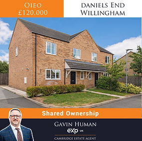


Station Farm, Wisbech St Mary
Station Farm, Wisbech St Mary, PE13
Price Guide: £775,000
You can view the key information about this property including local schools and transport below, and by downloading the digital brochure or visiting the webpage below.
Property Type
Bedrooms
Council Tax
Square footage
EPC Rating
Age
Last sold date
Title Number
Plot size
Heating
Tenure
LOCAL AREA
Local Authority
Flood Risk River & Seas
Flood Risk surface water
Conservation Area
CONNECTIVITY
Estimated broadband speeds:
Standard
Superfast
Ultrafast
Cable/Satellite TV availability
BT
Sky
Virgin Media
Mobile Signals (based on calls indoors)
EE
3 (Three)
O2
Vodafone
SCHOOLS
Primary
Wisbech St Mary CofE Academy
Leverington Primary School
GorefieldPrimary School
Peckover Primary School
Secondary
Wisbech Grammar School
Olive AP Academy
Cambian Wisbech School
TRANSPORT (NATIONAL)
National Rail Stations
March
Manea
Peterborough
Trunk Roads/Motorways
M11 J14
A1(M) J16
A1(M) J15
Airports/Helipads
Cambridge Airport
Stansted Airport
Luton Airport
Norwich Airport
TRANSPORT (LOCAL)
Bus stops
St Marys Close
The Jetty
Station Road
10 year history of average house prices by property type in PE13
Detached +84.97 %
Semi-Detached +82.19%
Terraced +74.93%
PLEASE NOTE -Contains public sector information licensed under the Open Government License v3.0. The information contained within is for general information purposes and to act as a guide.
Sprift Technologies aggregate this date from a wide variety of sources and while we endeavour to keep the information up to date and correct, we make no representations or warranties of any kind, express or implied, about the completeness, accuracy, reliability, of the information or related graphics contained within this report for any purpose. Any reliance you place on such information is therefore strictly at your own risk. In no event will we be liable for any loss or damage including without limitation, indirect or consequential loss or damage, or any loss or damage whatsoever arising from loss of data or profits arising out of, or in connection with, the use of this report.
Extended Detached
5
Band E
3143 square feet (approximately)
Including outbuildings: 4445 sq feet
D
Before 1866
£625,000 in 2021
CB169066
0.44 acres
Oil
Freehold
Fenland
Very Low
Very Low
No
20 mbps
80 mbps
10,000 mbps
Yes
Yes
Yes
Red - You should not expect to receive a signal.
Red - You should not expect to receive a signal.
Green - Likely to have good coverage.
Amber - You may experience some problems
0.41 miles
2.07 miles
2.13 miles
2.43 miles
2.14 miles
2.27 miles
2.34 miles
6.64 miles
11.35 miles
21.2 miles
29.24 miles
19.7 miles
22.13 miles
31.27 miles
53.35 miles
57.39 miles
49.36 miles
0.24 miles
0.37 miles
0.5 miles
4 George Way, Chatteris
George Way, Chatteris, PE16
OIEO: £700,000
You can view the key information about this property including local schools and transport below, and by downloading the digital brochure or visiting the webpage below.
Property Type
Bedrooms
Council Tax
Square footage
EPC Rating
Age
Last sold date
Title Number
Plot size
Heating
Tenure
LOCAL AREA
Local Authority
Flood Risk River & Seas
Flood Risk surface water
Conservation Area
CONNECTIVITY
Estimated broadband speeds:
Standard
Superfast
Cable/Satellite TV availability
BT
Sky
Virgin
Mobile Signals (based on calls indoors)
EE
3 (Three)
O2
Vodafone
SCHOOLS
Primary
Kingsfield Primary School
Glebelands Primary School
Lionel Walden Primary School
Secondary
Cromwell Community College
Neale-Wade Academy
Abbey College
TRANSPORT (NATIONAL)
National Rail Stations
Manea Rail Station
March Rail Station
Whittlesea Rail Station
Huntingdon Rail Station
Trunk Roads/Motorways
M11 J14
M11 J13
M11 J12
A1 (M) J14
A1 (M) J15
Airports/Helipads
Stansted Airport
Luton Airport
TRANSPORT (LOCAL)
Bus stops
Little Curf Drove
Doddington Road
Fenland Way
10 year history of average house prices by property type in PE15
Detached. +84.97 %
Semi-Detached +82.19 %
Terraced +74.93 %
Detached house
Four
Band F
2562 sqft approx 3778 sqft (Including Annexe)
B
2016
June 2017
CB400582
0.2 acres
Air source heat pump
Freehold
Fenland District Council
No
Medium
No
13 mbps
47 mbps
Yes
Yes
Yes
Green - Likely to have good coverage.
Amber - You may experience some problems.
N/A
Amber - You may experience some problems.
0.79 miles
1.02 miles
2.36 miles
1.27 miles
5.3 miles
5.92 miles
6.21 miles
6.82 miles
8.76 miles
15.3 miles
16.16 miles
17.66 miles
19.2 miles
13.87 miles
13.3 miles
41.03 miles
44.24 miles
0.14 miles
0.23 miles
0.28 miles
2 George Way, Chatteris
George Way, Chatteris, PE16
OIEO: £700,000
You can view the key information about this property including local schools and transport below, and by downloading the digital brochure or visiting the webpage below.
Property Type
Bedrooms
Council Tax
Square footage
EPC Rating
Age
Last sold date
Title Number
Plot size
Heating
Tenure
LOCAL AREA
Local Authority
Flood Risk River & Seas
Flood Risk surface water
Conservation Area
CONNECTIVITY
Estimated broadband speeds:
Standard
Superfast
Cable/Satellite TV availability
BT
Sky
Virgin
Mobile Signals (based on calls indoors)
EE
3 (Three)
O2
Vodafone
SCHOOLS
Primary
Kingsfield Primary School
Glebelands Primary School
Lionel Walden Primary School
Secondary
Cromwell Community College
Neale-Wade Academy
Abbey College
TRANSPORT (NATIONAL)
National Rail Stations
Manea Rail Station
March Rail Station
Whittlesea Rail Station
Huntingdon Rail Station
Trunk Roads/Motorways
M11 J14
M11 J13
M11 J12
A1 (M) J14
A1 (M) J15
Airports/Helipads
Stansted Airport
Luton Airport
TRANSPORT (LOCAL)
Bus stops
Little Curf Drove
Doddington Road
Fenland Way
10 year history of average house prices by property type in PE15
Detached. +84.97 %
Semi-Detached +82.19 %
Terraced +74.93 %
Detached house
Four
Band F
2508 sqft approx 3509 sqft (Including Annexe)
B
2021
June 2021
CB423833
0.2 acres
Gas Central Heating
Freehold
Fenland District Council
No
Medium
No
13 mbps
47 mbps
Yes
Yes
Yes
Green - Likely to have good coverage.
Amber - You may experience some problems.
N/A
Amber - You may experience some problems.
0.79 miles
1.02 miles
2.36 miles
1.27 miles
5.3 miles
5.92 miles
6.21 miles
6.82 miles
8.76 miles
15.3 miles
16.16 miles
17.66 miles
19.2 miles
13.87 miles
13.3 miles
41.03 miles
44.24 miles
0.14 miles
0.23 miles
0.28 miles
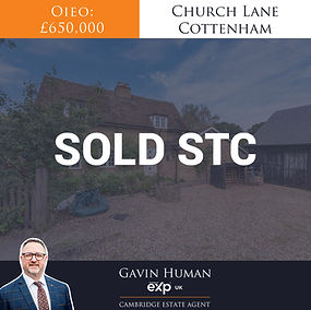
Groves Way, Cottenham
Groves Way, Cottenham, CB24
Price Guide: £575,000
You can view the key information about this property including local schools and transport below, and by downloading the digital brochure or visiting the webpage below.
Property Type
Bedrooms
Council Tax
Square footage
EPC Rating
Age
Last sold date
Title Number
Plot size
Heating
Tenure
LOCAL AREA
Local Authority
Flood Risk River & Seas
Flood Risk surface water
Conservation Area
CONNECTIVITY
Upload
Download
Full Fibre Available
Cable/Satellite TV availability
BT
Sky
Virgin
Mobile Signals (based on calls indoors)
EE
3 (Three)
O2
SCHOOLS
Primary
Cottenham
Hison & impington Brook
Pathfinder Cof E
Secondary
Cottenham Village College
Northstowe Secondary College
Impington Village College
TRANSPORT (NATIONAL)
National Rail Stations
Cambridge North
Waterbeach
Cambridge
Trunk Roads/Motorways
M11 J14
M11 J13
M11 J12
M11 J11
Airports/Helipads
Cambridge
Stansted
Luton
TRANSPORT (LOCAL)
Bus stops
Rampton Road
Allotment Gardens
Manse Drive
Detached
Three
Band E
915 square feet
B
2022
2022
CB472287
TBC
Gas Central Heating
Freehold
South Cambridge
Very Low
Very Low
No
115Mbps
1600Mbps
YES
YES
YES
YES
Amber - You may experience some problems.
Amber - You may experience some problems.
Amber - You may experience some problems.
0.41 miles
2.35 miles
2.38 miles
0.67 miles
1.91 Miles
2.69 miles
4.74 miles
4.03 miles
6.47 miles
4.07 miles
5.3 miles
6.85 miles
8.72 miles
6.21 miles
28.11 miles
34.94 miles
0.08 miles
0.13 miles
0.27 miles
Larkspur Cottage, Little Thurlow

Larkspur Cottage, Little Thurlow, CB9
OIEO: £525,000
You can view the key information about this property including local schools and transport below, and by downloading the digital brochure or visiting the webpage below.
Property Type
Bedrooms
Council Tax
Square footage
EPC Rating
Age
Last sold date
Title Number
Plot size
Heating
Tenure
LOCAL AREA
Local Authority
Flood Risk River & Seas
Flood Risk surface water
Conservation Area
CONNECTIVITY
Estimated broadband speeds:
Upload
Download
Full Fibre Available
Cable/Satellite TV availability
BT
Sky
Virgin
Mobile Signals (based on calls indoors)
EE
3 (Three)
O2
Vodafone
SCHOOLS
Primary
Thurlow Primary
New Cangle Community Primary
Kedington Primary Academy
Barnadiston Hall Preparatory School
Secondary
Samuel Ward Academy
Castle Manor Academy
TRANSPORT (NATIONAL)
National Rail Stations
Kennett
Dullingham
Newmarket
Trunk Roads/Motorways
M11 J9
M11 J10
M11 J11
M11 J12
Airports/Helipads
Cambridge airport
Stansted airport
Luton airport
TRANSPORT (LOCAL)
Bus stops
The Garage
The Old Rose and Crown
Pound Green 0.41 miles
Post Box 0.7 miles
10 year history of average house prices by property type in CB8
Detached +74.63 %
Semi-Detached. + 71.48%
Terraced +68.43%
Detached cottage
Three
Band F
1431sqft
D
1617
2014
SK121327
0.16 acres (STS)
Oil Fired Central Heating
Freehold
West Suffolk District Council
Very Low
Very Low
YES
15 mbps
76 mbps
NO
Yes
Yes
No
Amber - You may experience some problems.
Amber - You may experience some problems.
Green - Likely to have good coverage.
Amber - You may experience some problems.
0.34 miles
2.73 miles
2.86 miles
3.3 miles
2.7 miles
3.11miles
14 miles
6.9 miles
9.4 miles
12.07 miles
13.42 miles
14.88 miles
16.5 miles
12.85 miles
8.32 miles
39.21 miles
0.19 miles
0.26 miles
0.41 miles
0.7 miles
Beech Close, Warboys
Beech Close, Warboys, PE28
OIEO: £475,000
You can view the key information about this property including local schools and transport below, and by downloading the digital brochure or visiting the webpage below.
Property Type
Bedrooms
Council Tax
Square footage
EPC Rating
Age
Last sold date
Title Number
Plot size
Heating
Tenure
LOCAL AREA
Local Authority
Flood Risk River & Seas
Flood Risk surface water
Conservation Area
CONNECTIVITY
Upload
Download
Full Fibre Available
Cable/Satellite TV availability
BT
Sky
Virgin
Mobile Signals (based on calls indoors)
EE
3 (Three)
O2
Vodafone
SCHOOLS
Primary
Warboys Primary
Bury CofE Primary
Upwood Primary
Secondary
Abbey College
St Ivo Academy
TRANSPORT (NATIONAL)
National Rail Stations
Huntingdon
Whittlesea
Trunk Roads/Motorways
A1(M) J14
A1(M) J13
A1(M) J15
M11 J14
Airports/Helipads
Cambridge airport
Stansted airport
Luton airport
TRANSPORT (LOCAL)
Bus stops
Church Road
Ramsey Road
High Street
DeRamsey Court
10 year history of average house prices by property type in CB8
Detached
Semi-Detached
Terraced
Detached House
Four
Band E
1539sqft
D
1999
2018
CB228076
0.09 (STS)
Gas Fired Central Heating
Freehold
Huntingdon District Council
Very Low
Very Low
No
115 mbps
1600 mbps
YES
Yes
Yes
No
Green - Likely to have good coverage
Amber - You may experience some problems.
Green - Likely to have good coverage
Amber - You may experience some problems.
0.4 miles
2.82 miles
3.1 miles
3.27 miles
4.83miles
6.76 miles
10.4 miles
7.38miles
7.71 miles
8.11 miles
13.22 miles
17.37 miles
38.2 miles
38.14miles
0.17 miles
0.24 miles
0.24 miles
0.29 miles
+83.95 %
+ 81.72%
+74.33%
The Limes, Doddington
The Limes, Doddington, PE15
OIEO: £475,000
You can view the key information about this property including local schools and transport below, and by downloading the digital brochure or visiting the webpage below.
KEY INFORMATION
Type
Bedrooms
Council Tax
Square footage
EPC Rating
Age
Last sold date
Title Number
Plot size
Heating
Tenure
LOCAL AREA
Local Authority
Flood Risk River & Seas
Flood Risk surface water
Conservation Area
CONNECTIVITY
Estimated broadband speeds:
Standard
Superfast
Ultrafast
Cable/Satellite TV availability
BT
Sky
Virgin
Mobile Signals (based on calls indoors)
Ee
3 (Three)
O2
Vodafone
SCHOOLS
Primary
Lionel Walden Primary School
Thomas Eaton Primary School
Glebelands Primary School
Secondary
Neale Wade Academy
Cromwell Community College
Kings Ely (Private)
TRANSPORT (NATIONAL)
National Rail Stations
March
Manea
Whittlesea
Trunk Roads/Motorways
M11 J14
M11 J13
M11 J12
M11 J11
Airports/Helipads
Stansted Airport
Luton airport
TRANSPORT (LOCAL)
Bus stops
Ingle's Lane
Childs Lane
New Street
10 year history of average house prices by property type in CB24
Detached +84.97%
Semi-Detached +82.19%
Terraced +74.93%
PLEASE NOTE -Contains public sector information licensed under the Open Government License v3.0. The information contained within is for general information purposes and to act as a guide.
Sprift Technologies aggregate this date from a wide variety of sources and while we endeavour to keep the information up to date and correct, we make no representations or warranties of any kind, express or implied, about the completeness, accuracy, reliability, of the information or related graphics contained within this report for any purpose. Any reliance you place on such information is therefore strictly at your own risk. In no event will we be liable for any loss or damage including without limitation, indirect or consequential loss or damage, or any loss or damage whatsoever arising from loss of data or profits arising out of, or in connection with, the use of this report.
Detached
4
Band C
1711 square feet (approximately)
E
1850s
2004 (£228,000)
CB191783
0.15 acres (STS)
Gas Fired Central Heating
Freehold
Fenland District Council
Very low
Very low
No
20 mbps
80 mbps
10000 mbps
Yes
Yes
Yes
Green - Likely to have good coverage.
Orange - You may experience some problems.
Orange - You may experience some problems.
Orange - You may experience some problems.
0.02 miles
1.19 miles
2.84 miles
2.96 miles
3.26 miles
17.1 miles
4.52 miles
4.74 miles
8.5 miles
M11 J14 18.2 miles
M11 J13 19.68 miles
M11 J12 21.23 miles
M11 J11 17.85 miles
42.84 miles
46.57 miles
0.1 mile
0.11 miles
0.18 miles
Manor Farm, Coveney
Manor Farm, Coveney, CB6 2DJ
OIEO: £1,500,000
You can view the key information about this property including local schools and transport below, and by downloading the digital brochure or visiting the webpage below.
KEY INFORMATION
Property Type
Bedrooms
Council Tax
Square footage
EPC Rating
Age
Last sold date
Title Number
Plot size
Heating
Tenure
LOCAL AREA
Local Authority
Flood Risk River & Seas
Flood Risk surface water
Conservation Area
CONNECTIVITY
Estimated broadband speeds:
Standard
Superfast
Ultrafast
Cable/Satellite TV availability
BT
Sky
Virgin
Mobile Signals (based on calls indoors)
EE
3 (Three)
O2
Vodafone
SCHOOLS
Primary
Rackham CofE Primary
Downham Feoffees Primary
Ely St Johns Community Primary
Secondary
Witchford Village College
Ely College
Kings Ely (Private)
TRANSPORT (NATIONAL)
National Rail Stations
Ely
Manea
Trunk Roads/Motorways
M11 J14
M11 J13
M11 J12
M11 J11
Airports/Helipads
Cambridge Airport
Stansted airport
TRANSPORT (LOCAL)
Bus stops
Short Lane
Main Road
Hale fen Lane
10 year history of average house prices by property type in CB6
Detached +86.33 %
Semi-Detached +84.48%
Terraced +76.36%
PLEASE NOTE -Contains public sector information licensed under the Open Government License v3.0. The information contained within is for general information purposes and to act as a guide.
Sprift Technologies aggregate this date from a wide variety of sources and while we endeavour to keep the information up to date and correct, we make no representations or warranties of any kind, express or implied, about the completeness, accuracy, reliability, of the information or related graphics contained within this report for any purpose. Any reliance you place on such information is therefore strictly at your own risk. In no event will we be liable for any loss or damage including without limitation, indirect or consequential loss or damage, or any loss or damage whatsoever arising from loss of data or profits arising out of, or in connection with, the use of this report.
Detached Farmhouse
Six
Band G
House 3207 sqft
Grain Store 6469 sqft
Barn 4639 sqft
Garage and Stables 1529 sqft
(app approx)
NA
16th Century
NA
CB295807
8.78 acres (STS)
Oil Fired Central Heating
Freehold
East Cambridgeshire District Council
Very Low
Very Low
No
2 mbps
80 mbps
1800 mbps
Yes
Yes
No
Amber - You may experience some problems.
Red - You should not expect to receive a signal.
Red - You should not expect to receive a signal.
Amber - You may experience some problems.
2.05 miles
2.73 miles
2.82 miles
1.98 miles
2.74 miles
3.43 miles
3.79 miles
5.87 miles
13.39 miles
14.64 miles
16.16 miles
17.85 miles
19.6 miles
36.41 miles
0.13 miles
0.27 miles
1.08miles
Black Bank Lane, Little Downham
Black Bank Road, Little Downham, CB6 2UA
Price Guide: £750,000
You can view the key information about this property including local schools and transport below, and by downloading the digital brochure or visiting the webpage below.
KEY INFORMATION
Property Type
Bedrooms
Council Tax Band
Square footage
EPC Rating
Age
Last sold date
Title Number
Plot size
Heating
Tenure
LOCAL AREA
Local Authority
Flood Risk River & Seas
Flood Risk surface water
Conservation Area
CONNECTIVITY
Estimated broadband speeds:
Standard
Superfast
Cable/Satellite TV availability
BT
Sky
Virgin
Mobile Signals (based on calls indoors)
EE Red
3 (Three)
O2
Vodafone
SCHOOLS
Primary
Littleport Primary
Millfield Primary School
Downham Feoffees Primary
Secondary
Vista Academy
Ely College
Kings Ely (Private)
TRANSPORT (NATIONAL)
National Rail Stations
Littleport
Ely
Trunk Roads/Motorways
M11 J14
M11 J13
M11 J12
M11 J11
M11 J10
Airports/Helipads
Cambridge Airport
Stansted Airport
TRANSPORT (LOCAL)
Bus stops
Black Bank Road
Noahs Way
Queens Road
10 year history of average house prices by property type in CB6
Detached +86.33 %
Semi-Detached +84.48%
Terraced +76.36%
PLEASE NOTE -Contains public sector information licensed under the Open Government License v3.0. The information contained within is for general information purposes and to act as a guide.
Sprift Technologies aggregate this date from a wide variety of sources and while we endeavour to keep the information up to date and correct, we make no representations or warranties of any kind, express or implied, about the completeness, accuracy, reliability, of the information or related graphics contained within this report for any purpose. Any reliance you place on such information is therefore strictly at your own risk. In no event will we be liable for any loss or damage including without limitation, indirect or consequential loss or damage, or any loss or damage whatsoever arising from loss of data or profits arising out of, or in connection with, the use of this report.
Detached bungalow
Three
Band D
056 sqft approx (5015 sqft inc barn and stables)
E
1950s
2012
CB299777
7.16 acres
Oil Fired Central Heating
Freehold
East Cambridgeshire District Council
Medium
Very low
Yes
5 mbps
49 mbps
Yes
Yes
No
Amber - You may experience some problems
Amber - You may experience some problems
Green - Likely to have good coverage.
Amber - You may experience some problems
0.52 miles
0.97 miles
2.44 miles
0.76 miles
3.60 miles
4.47 miles
1.59 miles
4.77 miles
17.99 miles
19.09 miles
20.56 miles
21.98 miles
25.67
17.09 miles
39.45 miles
0.31 miles
0.32 miles
0.55 miles
Mill Hill Lane, March
Mill Hill Lane, March, PE15 9QB
OIEO: £600,000
You can view the key information about this property including local schools and transport below, and by downloading the digital brochure or visiting the webpage below.
KEY INFORMATION
Property Type
Bedrooms
Council Tax Band
Square footage
EPC Rating
Age
Last sold date
Title Number
Plot size
Heating
Tenure
LOCAL AREA
Local Authority
Flood Risk River & Seas
Flood Risk surface water
Conservation Area
CONNECTIVITY
Estimated broadband speeds:
Standard
Superfast
Cable/Satellite TV availability
BT
Sky
Virgin
Mobile Signals (based on calls indoors)
EE Red
3 (Three) Red
O2 Amber
Vodafone Amber
SCHOOLS
Primary
Cavalry Primary School
Westwood Primary School
All Saints Interchurch Academy
Secondary
Neale-Wade Academy
Cromwell Community College
Kings Ely
TRANSPORT (NATIONAL)
National Rail Stations
March Rail Station
Manea Rail Station
Huntingdon Rail Station
Peterborough
Trunk Roads/Motorways
M11 J14
M11 J13
M11 J12
A1 (M) J14
A1 (M) J15
Airports/Helipads
Stansted Airport
Luton Airport
TRANSPORT (LOCAL)
Bus stops
Lambs Hill Drove
Wimblington Road
Neale Wade College
10 year history of average house prices by property type in CB6
Detached +86.33 %
Semi-Detached +84.48%
Terraced +76.36%
PLEASE NOTE -Contains public sector information licensed under the Open Government License v3.0. The information contained within is for general information purposes and to act as a guide.
Sprift Technologies aggregate this date from a wide variety of sources and while we endeavour to keep the information up to date and correct, we make no representations or warranties of any kind, express or implied, about the completeness, accuracy, reliability, of the information or related graphics contained within this report for any purpose. Any reliance you place on such information is therefore strictly at your own risk. In no event will we be liable for any loss or damage including without limitation, indirect or consequential loss or damage, or any loss or damage whatsoever arising from loss of data or profits arising out of, or in connection with, the use of this report.
Detached house
Five
Band F
3336 sqft approx
B
2018
une 2018
CB32219
0.16 acres
Gas Central Heating
Freehold
Fenland District Council
No
High
No
24mbps
1000 mbps
Yes
Yes
No
Amber - You may experience some problems.
Red - You should not expect to receive a signal.
Amber - You may experience some problems.
Amber - You may experience some problems.
1.08 miles
1.61 miles
1.79 miles
0.54 miles
5.81 miles
18.6 miles
1.97 miles
4.8 miles
22.1 miles
22.2 miles
20.69 miles
22.16 miles
14.17 miles
117.7 miles
16.31 miles
45.18 miles
49.08 miles
0.40 miles
0.41 miles
0.45 miles
Perseverance Cottage, Wentworth
Perseverance Cottage
Wentworth, Ely, CB6 3QG. OIEO: £750,000
You can view the key information about this property including local schools and transport below, and by downloading the digital brochure or visiting the webpage below.
KEY INFORMATION
Property Type
Bedrooms
Council Tax Band
Square footage
EPC Rating
Age
Last sold date
Title Number
Plot size
Heating
Tenure
LOCAL AREA
Local Authority
Flood Risk River & Seas
Flood Risk surface water
Conservation Area
CONNECTIVITY
Estimated broadband speeds:
Standard
Superfast
Cable/Satellite TV availability
BT
Sky
Virgin
Mobile Signals (based on calls indoors)
EE Red
3 (Three) Red
O2 Amber
Vodafone Amber
SCHOOLS
Primary
The Rackham C of E Primary School
Sutton C of E Primary School
Robert Arkenstall Primary School
Secondary
Witchford Village College
Ely College
Kings Ely
TRANSPORT (NATIONAL)
National Rail Stations
Ely Rail Station
Manea Rail Station
Cambridge North Rail Station
Huntingdon Rail Station
Trunk Roads/Motorways
M11 J14
M11 J13
M11 J12
M11 J11
M11 J10
Airports/Helipads
Stansted Airport
Cambridge Airport
TRANSPORT (LOCAL)
Bus stops
Church Road
New Road
Granta Close
10 year history of average house prices by property type in CB6
Detached +79.46 %
Semi-Detached +79.21 %
Terraced +72.95 %
PLEASE NOTE -Contains public sector information licensed under the Open Government License v3.0. The information contained within is for general information purposes and to act as a guide.
Sprift Technologies aggregate this date from a wide variety of sources and while we endeavour to keep the information up to date and correct, we make no representations or warranties of any kind, express or implied, about the completeness, accuracy, reliability, of the information or related graphics contained within this report for any purpose. Any reliance you place on such information is therefore strictly at your own risk. In no event will we be liable for any loss or damage including without limitation, indirect or consequential loss or damage, or any loss or damage whatsoever arising from loss of data or profits arising out of, or in connection with, the use of this report.
Detached Cottage
3
Band E
1690 sqft approx
2626 sqft (Including garage and workshop)
E
500
2004
CB283515
0.66 acres
Oil
Freehold
East Cambridgeshire District Council
No
Very low
Very low
8 mbps
1000 mbps
Yes
Yes
No
Amber - You may experience some problems.
Red - You should not expect to receive a signal.
Amber - You may experience some problems.
Amber - You may experience some problems.
SCHOOLS
1.67 miles
1.88 miles
2.19 miles
1.91 miles
3.92 miles
4.05 miles
4.52 miles
7.83miles
14.5 miles
22.4 miles
11.42 miles
12.64 miles
14.17 miles
15.84 miles
19.88 miles
34.4 miles
12.4 miles
0.23 miles
0.62 miles
0.93 miles
Rye Close, Littleport
Rye Close,
Littleport, CB6 1GH. Price Guide: £400,000
You can view the key information about this property including local schools and transport below, and by downloading the digital brochure or visiting the webpage below.
KEY INFORMATION
Property Type
Bedrooms
Council Tax Band
Square footage
EPC Rating
Age
Last sold date
Title Number
Plot size
Heating
Tenure
LOCAL AREA
Local Authority
Flood Risk River & Seas
Flood Risk surface water
Conservation Area
CONNECTIVITY
Estimated broadband speeds:
Standard
Superfast
Ultrafast
Cable/Satellite TV availability
BT
Sky
Virgin
Mobile Signals (based on calls indoors)
EE
3 (Three)
O2
Vodafone
SCHOOLS
Primary
Millfield Primary School
Littleport Community Primary School
Downham Feoffees Primary Academy
Isle of Ely Primary School
Secondary
Vista Academy Littleport
Highfield Littleport Academy
Ely College
Highfield Ely Academy
TRANSPORT (NATIONAL)
National Rail Stations
Littleport
Ely
Trunk Roads/Motorways
M11 J14
M11 J13
M11 J12
M11 J11
M11 J10
Airports/Helipads
Stansted Airport
Luton Airport
TRANSPORT (LOCAL)
Bus stops
Atkins Close
Eastfields
Friars Way
Health Centre
Upton Lane
10 year history of average house prices by property type in CB6
Detached +79.46%
Semi-Detached +79.21%
Terraced +72.95%
PLEASE NOTE -Contains public sector information licensed under the Open Government License v3.0. The information contained within is for general information purposes and to act as a guide.
Sprift Technologies aggregate this date from a wide variety of sources and while we endeavour to keep the information up to date and correct, we make no representations or warranties of any kind, express or implied, about the completeness, accuracy, reliability, of the information or related graphics contained within this report for any purpose. Any reliance you place on such information is therefore strictly at your own risk. In no event will we be liable for any loss or damage including without limitation, indirect or consequential loss or damage, or any loss or damage whatsoever arising from loss of data or profits arising out of, or in connection with, the use of this report.
Semi-detached house
5
Band E
1830 square feet (approximately)
C
2007
N/A
CB360342
0.05 acres
Gas Central Heating
Freehold
East Cambridgeshire District Council
No
Low
No
16 mbps
80 mbps
1000 mbps
Yes
Yes
No
Green - Likely to have good coverage.
Amber - You may experience some problems.
Green - Likely to have good coverage.
Amber - You may experience some problems.
SCHOOLS
0.27 miles
0.36 miles
2.74 miles
3.26 miles
0.65 miles
0.83 miles
3.58 miles
3.75 miles
1.04 miles
4.52 miles
18.03 miles
19.08 miles
20.53 miles
21.97 miles
25.46 miles
39.07 miles
48.87 miles
0.3 miles
0.22 miles
0.31 miles
0.34 miles
0.28 miles
Thatched Cottage, Hemingford Abbots
Thatched Cottage, Hemingford Abbots, PE28
OIEO: £3,000,000
You can view the key information about this property including local schools and transport below, and by downloading the digital brochure or visiting the webpage below.
KEY INFORMATION
Property Type
Bedrooms
Council Tax Band
Square footage
EPC Rating
Age
Last sold date
Title Number
Plot size
Heating
Tenure
Walls
LOCAL AREA
Local Authority
Flood Risk River & Seas
Flood Risk surface water
Conservation Area
CONNECTIVITY
Estimated broadband speeds:
Standard
Superfast
Ultrafast
Cable/Satellite TV availability
BT
Sky
Virgin
Mobile Signals (based on calls indoors)
EE
3 (Three)
O2
Vodafone
SCHOOLS
Primary
Houghton Primary School
Hemingford Grey Primary School
Wyton on the Hill Community Primary
Secondary
Aurora Fairway School
St Ivo Academy
Spring Common Academy
St Peter's School
TRANSPORT (NATIONAL)
National Rail Stations
Huntingdon
St Neots
Trunk Roads/Motorways
A1(M) J13
A1(M) J14
A1(M) J15
M11 J14
M11 J13
Airports/Helipads
Cambridge Airport
Luton Airport
Stansted Airport
TRANSPORT (LOCAL)
Bus stops
Church Lane
The Clock Tower
New Road
Ware Lane
Manor Close
10 year history of average house prices by property type in PE15
Detached +83.95 %
Semi-Detached +81.72%
Terraced +74.33%
PLEASE NOTE -Contains public sector information licensed under the Open Government License v3.0. The information contained within is for general information purposes and to act as a guide.
Sprift Technologies aggregate this date from a wide variety of sources and while we endeavour to keep the information up to date and correct, we make no representations or warranties of any kind, express or implied, about the completeness, accuracy, reliability, of the information or related graphics contained within this report for any purpose. Any reliance you place on such information is therefore strictly at your own risk. In no event will we be liable for any loss or damage including without limitation, indirect or consequential loss or damage, or any loss or damage whatsoever arising from loss of data or profits arising out of, or in connection with, the use of this report.
Detached
6
Band H
10,258 (approximately)
D
1996
1995
CB183438
1.97 acres
Oil
Freehold
Timber Frame
Huntingdonshire
None
Medium
Yes
2 mbps
50 mbps
1000 mbps
Yes
Yes
No
None
Amber - You may experience some problems.
Amber - You may experience some problems.
Amber - You may experience some problems.
SCHOOLS
0.56 miles
1.36 miles
1.40 miles
1.75 miles
1.83 miles
2.09 miles
2.62 miles
2.73 miles
8.23 miles
5.96 miles
6.37 miles
9.39 miles
10.42 miles
11.7 miles
18 miles
32.57 miles
34.42 miles
0.42 miles
0.61 miles
0.62 miles
0.65 miles
0.68 miles
Elm Road, March
Elm Road, March, PE15 8PS
OIEO: £650,000
You can view the key information about this property including local schools and transport below, and by downloading the digital brochure or visiting the webpage below.
KEY INFORMATION
Property Type
Bedrooms
Council Tax Band
Square footage
EPC Rating
Age
Last sold date
Title Number
Plot size
Heating
Tenure
LOCAL AREA
Local Authority
Flood Risk River & Seas
Flood Risk surface water
Conservation Area
CONNECTIVITY
Estimated broadband speeds:
Standard
Superfast
Cable/Satellite TV availability
BT
Sky
Virgin
Mobile Signals (based on calls indoors)
EE
3 (Three)
O2
Vodafone
SCHOOLS
Primary
All Saints Interchurch Academy
Westwood Primary School
Cavalry Primary School
Secondary
Cromwell Community College
Neale-Wade Academy
Abbey College
TRANSPORT (NATIONAL)
National Rail Stations
Manea Rail Station
March Rail Station
Whittlesea Rail Station
Huntingdon Rail Station
Trunk Roads/Motorways
M11 J14
M11 J13
M11 J12
A1 (M) J14
A1 (M) J15
Airports/Helipads
Stansted Airport
TRANSPORT (LOCAL)
Bus stops
Little Curf Drove
Doddington Road
Fenland Way
10 year history of average house prices by property type in PE15
Detached +84.97
Semi-Detached +82.19
Terraced +74.926%
PLEASE NOTE -Contains public sector information licensed under the Open Government License v3.0. The information contained within is for general information purposes and to act as a guide.
Sprift Technologies aggregate this date from a wide variety of sources and while we endeavour to keep the information up to date and correct, we make no representations or warranties of any kind, express or implied, about the completeness, accuracy, reliability, of the information or related graphics contained within this report for any purpose. Any reliance you place on such information is therefore strictly at your own risk. In no event will we be liable for any loss or damage including without limitation, indirect or consequential loss or damage, or any loss or damage whatsoever arising from loss of data or profits arising out of, or in connection with, the use of this report.
Detached house
Six
Band G
3251 sqft approx 4282 sqft (Including Annexe)
B
2018
June 2018
CB438432
0.33 acres
Gas Central Heating
Freehold
Fenland District Council
No
Low
No
25 mbps
1000 mbps
Yes
Yes
No
Amber
Red
Amber
Amber
0.86 miles
1.07 miles
1.95 miles
1.27 miles
5.3 miles
5.92 miles
6.21 miles
6.82 miles
8.76 miles
15.3 miles
16.16 miles
7.66 miles
19.2 miles
13.87 miles
13.3 miles
41.03 miles
44.24 miles
0.14 miles
0.23 miles
0.28 miles
Stanley House, Wimblington
Stanley House,
Wimblington, PE15 0RR. OIEO: £700,000
You can view the key information about this property including local schools and transport below, and by downloading the digital brochure or visiting the webpage below.
KEY INFORMATION
Property Type
Bedrooms
Council Tax Band
Square footage
EPC Rating
Age
Last sold date
Title Number
Plot size
Heating
Tenure
LOCAL AREA
Local Authority
Flood Risk River & Seas
Flood Risk surface water
Conservation Area
CONNECTIVITY
Estimated broadband speeds:
Standard
Ultrafast
Cable/Satellite TV availability
BT
Sky
Virgin
Mobile Signals (based on calls indoors)
EE
3 (Three)
O2
Vodafone
SCHOOLS
Primary
Thomas Eaton Primary School
Lionel Walden Primary School
Cavalry Primary School
Burrowmoor Primary School
Secondary
Neale-Wade Academy
Cromwell Community College
TRANSPORT (NATIONAL)
National Rail Stations
March
Manea
Whittlesea
Trunk Roads/Motorways
M11 J14
M11 J13
M11 J12
M11 J11
M11 J10
Airports/Helipads
Cambridge
Stansted
Luton
Norwich
TRANSPORT (LOCAL)
Bus stops
Bridge Lane
Linwood Lane
March Road
10 year history of average house prices by property type in CB25
Detached +84.97%
Semi-Detached +82.19%
Terraced +74.93%
PLEASE NOTE -Contains public sector information licensed under the Open Government License v3.0. The information contained within is for general information purposes and to act as a guide.
Sprift Technologies aggregate this date from a wide variety of sources and while we endeavour to keep the information up to date and correct, we make no representations or warranties of any kind, express or implied, about the completeness, accuracy, reliability, of the information or related graphics contained within this report for any purpose. Any reliance you place on such information is therefore strictly at your own risk. In no event will we be liable for any loss or damage including without limitation, indirect or consequential loss or damage, or any loss or damage whatsoever arising from loss of data or profits arising out of, or in connection with, the use of this report.
Detached
5
Band F
4305ft (approximately)
C
After 2007
2020
CB455289
0.19 acres
Boiler, and underfloor heating, oil
Freehold
East Cambridgeshire
No risk
Very Low
No
23 mbps
1000 mbps
Yes
Yes
Yes
Amber - You may experience some problems.
Amber - You may experience some problems.
Amber - You may experience some problems.
Amber - You may experience some problems.
SCHOOLS
0.59 miles
1.62 miles
1.81 miles
1.99 miles
1.38 miles
4.82 miles
2.97 miles
4.18 miles
8.82 miles
19.63 miles
21.09 miles
22.65 miles
24.7 miles
16.1 miles
21.62 miles
43.99 miles
48.24 miles
51.29 miles
0.11 miles
0.14 miles
0.21 miles
Stags Holt Farm, Coldham Bank
Stags Holt Farm, Coldham Bank
March, PE15 0BS. Price Guide: £600,000
You can view the key information about this property including local schools and transport below, and by downloading the digital brochure or visiting the webpage below.
KEY INFORMATION
Property Type
Bedrooms
Council Tax Band
Square footage
EPC Rating
Age
Last sold date
Title Number
Plot size
Heating
Tenure
LOCAL AREA
Local Authority
Flood Risk River & Seas
Flood Risk surface water
Conservation Area
CONNECTIVITY
Estimated broadband speeds:
Standard TBC
Superfast TBC
Ultrafast TBC
Cable/Satellite TV availability
BT
Sky
Virgin
Mobile Signals (based on calls indoors)
EE Red
3 (Three) Red
O2 Amber
Vodafone Amber
SCHOOLS
Primary
All Saints Interchurch Academy
Westwood Primary
Guyhirn CofE Primary
Burrowmoor Primary
Secondary
Neale-Wade Academy
TRANSPORT (NATIONAL)
National Rail Stations
March
Manea
Peterborough
Trunk Roads/Motorways
M11 J14
M11 J13
M11 J12
M11 J15
Airports/Helipads
Cambridge Airport
Stansted Airport
TRANSPORT (LOCAL)
Bus stops
March Lane
Station Road
The Forge
10 year history of average house prices by property type in PE15
Detached +84.97 %
Semi-Detached +82.19%
Terraced +74.93%
PLEASE NOTE -Contains public sector information licensed under the Open Government License v3.0. The information contained within is for general information purposes and to act as a guide.
Sprift Technologies aggregate this date from a wide variety of sources and while we endeavour to keep the information up to date and correct, we make no representations or warranties of any kind, express or implied, about the completeness, accuracy, reliability, of the information or related graphics contained within this report for any purpose. Any reliance you place on such information is therefore strictly at your own risk. In no event will we be liable for any loss or damage including without limitation, indirect or consequential loss or damage, or any loss or damage whatsoever arising from loss of data or profits arising out of, or in connection with, the use of this report.
Single storey dwelling
3
TBC
2293 square feet (approximately)
TBC
New build
N/A
CB149158
TBC
Ground source heat pump
Freehold
Fenland District Council
No
very low
No
Yes
Yes
No
Amber - You may experience some problems.
Amber - You may experience some problems.
Red - You should not expect to receive a signal.
Red - You should not expect to receive a signal.
SCHOOLS
2.21 miles
2.52 miles
2.99 miles
3.02
3.49miles
2.04 miles
3.57 miles
20.1 miles
24.32 miles
25.76 miles
27.32 miles
19.58 miles
25.99 miles
48.32 miles
0.78 miles
1.42 miles
1.05 miles